Last summer, Iridium® Radio Frequency Engineering intern Bharath Kumar Nagalamadagu Govindaraju developed an Iridium Connected™ Agronomical Management System prototype, called Green Box, for his summer project. Working under Dr. Omid Nia, Iridium’s Associate Director of Product Engineering & Certification, Bharath’s prototype aims to combat issues faced by the agriculture industry, to include climate change, water scarcity, and pests.
Bharath and Iridium Engineer Ahmad Tamanna accept the Best Paper and Best Presenter awards from IEEE AIIoT 2024 General Chair, Dr. Son T. Vuong
Adding to their list of achievements, Bharath and Omid recently celebrated personal academic milestones—with Bharath earning a master’s degree and Omid a Ph.D., both from George Mason University.
Dr. Madriz, an entomologist, zoologist, National Geographic Explorer, and Fulbright Fellow, has devoted his career to exploring insect diversity through images and stories of exploration, science, and human connections.
During his expeditions, Isaí relies on Iridium to keep him connected with colleagues, friends, family, and help should it be needed—utilizing the Iridium GO!®, Iridium GO! exec®, and Iridium Extreme®.
What better way to celebrate Insect Week than with all the creepy, crawly (and sometimes cute!) creatures that play a critical role in our ecosystem. Isaí’s work is a testament to how little things make a big difference in the world around us.
Dr. Madriz explores the remote Bernard glacier at the southern end of the southern Patagonia Ice Field.
Learn more about some of the insects Isaí has found on his #IridiumConnected adventures:
Caterpillar & Wasps
The pale-colored oblong structures on top of this caterpillar are cocoons of minute parasitoid wasps. Once the adult wasp emerges, it flies away to repeat the cycle. The caterpillar continues its life in the Patagonian steppe, unaware that it will never reach adulthood.
Owl Butterfly
Resting on a Heliconia plant in Costa Rica are an owl butterfly (top left) and a blue morpho (bottom right). The owl butterfly exhibits the impressive ventral coloration of its wings, its forewing reveals a pattern mimicking a snake head and its hindwing coloration resembles an owl’s eye. On the other side of the plant, the blue morpho displays the blue iridescence of the dorsal side of its wings.
Moth Flies
For most of their lives, these moth flies feed on decaying wood inside southern beech tree trunks. The larva (center) searches for a safe place to begin its metamorphosis. The developing adult will break open the larval skin and turn into a pale-yellow pupa (left). The horn-like protrusions on its head are the respiratory structures which must remain unobstructed during the metamorphosis process to ensure survival. As it nears the final moments of transformation within the pupal skin, the adult develops its final coloration (right) to complete its life cycle.
Click Beetle
The largest click beetle in Patagonia is feeding on a golf ball-sized fungus that parasitizes southern beech trees.
Midge
In the splash zone of a remote waterfall in Patagonia, a solitary midge emerges from its pupal skin next to a leafy liverwort. This individual will continue the evolutionary cycle that has made this group successful colonizers of this unique microhabitat.
Diving Beetle Larva
In the clear and gelid waterways of Chilean Patagonia, a predaceous diving beetle larva remains motionless while waiting for its prey to swim by.
Weevil
Under the dense canopy cover of the temperate rainforest of Patagonia, this weevil feeds on the nutritious juices that flow under the exposed bark of a southern beech tree branch.
The PX501 is a Windows-based solution intended for professionals across several industries, such as oil and gas – including offshore rigs, merchant shipping, law enforcement, non-government organizations (NGOs), agriculture, military, automotive, manufacturing, logistics, and more. This ruggedized tablet can withstand tough environments, while providing workers in the field with two-way data delivery via satellite, messaging, emailing, web browsing, and more, even in adverse weather conditions.
PX501 deployed in field services
“As a leader in providing ruggedized tablets for extreme environments, RuggON continues to deliver cutting-edge solutions that provide best-in-class options for their customers,” said Bryan Hartin, Executive Vice President of Sales and Marketing, Iridium. “When it comes to extreme communications, redundancy is essential. With the Iridium Connected PX501, users can confidently venture to even the most remote and extreme locations knowing that if they lose 5G or WiFi 6E connectivity, they will stay reliably connected with Iridium.”
PX501 for manufacturing
The PX501 is embedded with Iridium Short Burst Data® (SBD®) capabilities, giving users a reliable hybrid network connectivity experience when roaming in and out of terrestrial LTE, 3G/4G/5G, or Wi-Fi coverage. Iridium’s constellation of crosslinked satellites, blanketing the earth with weather-resilient L-band coverage, connects directly to the PX501 from space, making it a unique, reliable and ruggedized tablet experience.
Learn more about the Iridium Connected RuggON PX501 Rugged Tablet
Read the full announcement of the recently launched RuggON PX501 Rugged Tablet
About Iridium Communications Inc.
Iridium® is the only mobile voice and data satellite communications network that spans the entire globe. Iridium enables connections between people, organizations and assets to and from anywhere, in real time. Together with its ecosystem of partner companies, Iridium delivers an innovative and rich portfolio of reliable solutions for markets that require truly global communications. In 2019, the company completed a generational upgrade of its satellite network and launched its new specialty broadband service, Iridium Certus®. Iridium Communications Inc. is headquartered in McLean, Va., U.S.A., and its common stock trades on the Nasdaq Global Select Market under the ticker symbol IRDM. For more information about Iridium products, services and partner solutions, visit www.iridium.com.
Press Contact:
Jordan Hassin
Iridium Communications Inc. Jordan.Hassin@iridium.com
+1 (703) 287-7421
Investor Contact:
Kenneth Levy
Iridium Communications Inc. Ken.Levy@Iridium.com
+1 (703) 287-7570
With summer approaching, your pals at Iridium have created this handy, carefully-curated list of the best personal satellite messengers. Whether you’re climbing, biking, distance running, kayaking, backcountry camping, or just chillaxin’ in the deep woods, this suite of Iridium Connected™ solutions ensures you’ll maintain communications no matter how far you venture off the grid. Every product on this list communicates over the Iridium satellite network.
Why are Iridium Connected Satellite Messengers the Best?
They’re Reliable
Our network uses L-band satellite spectrum–giving end users a weather-resilient experience, which is invaluable for the outdoor, extreme sports, and adventure traveler communities. Additionally, the network is located in Low Earth Orbit (LEO), delivering a low-latency (or minimal delay) two-way communications experience.
They Have Unmatched Coverage
Every Iridium satellite is connected to its neighbors by crosslinks, creating a coverage web around the entire planet. Iridium remains the only satellite network that offers truly global coverage.
The Battery Life
The devices below can hold a charge for long stretches of time–with many providing hundreds of hours per charge.
Cost
When people think satellite communications, they think big bucks. However, because Iridium satellite messengers are small, lightweight, and have comparatively low power requirements, they are often more cost-effective than competing products with bigger antennas and greater power needs. There are also customized subscription plans available based on data needs to help manage budgets without having to sacrifice service quality.
And Now, the Best Satellite Messengers (in Alphabetical Order)
Small, mighty, and looking snazzy in lime green, the Bivy Stick provides a combination of convenience and safety. The device is perfect for any off-grid activity, enabling two-way connectivity for sending and receiving texts, emails, and weather reports. It also supports SOS monitoring and GPS capabilities. The device can be easily carried or mounted, with many different mounting configurations, making it an ideal on-the-go device to bring anywhere.
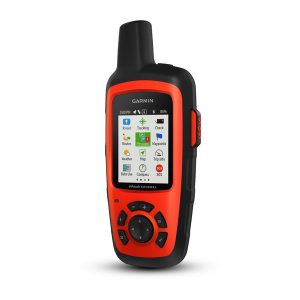
This satellite messenger packs a lot of capabilities into a diminutive frame. It is a rugged, handheld satellite communicator with two-way text messaging, 24/7 interactive SOS search and rescue monitoring (when triggered), and location sharing and tracking capabilities. It is also compatible with mobile devices using the Earthmate® app that gives access to downloadable maps, U.S. NOAA charts, color aerial images, and more. The device includes pre-loaded DeLorme® TOPO maps with GPS routing, a digital compass, barometric altimeter, and accelerometer.
Key Tech Specs:
Dimensions (L x W x H): 2.7″ x 6.5″ x 1.5″ (6.8 x 16.4 x 3.8 cm)
Weight: 7.5oz (213g)
Battery Life:
Up to 100 hours at 10-minute tracking mode (default)
Up to 75 hours at 10-minute tracking with 1-second logging
Up to 30 days at the 30-minute interval power save mode
Text from anywhere with this tough, tiny and piece of tech. Equipped with GPS, interactive SOS alerts, location sharing, and group messaging, users can communicate easily with loved ones (or even liked ones, or even “it’s complicated” ones) and access help if needed, no matter where they travel. The device can switch between cellular and satellite connectivity as needed and has 28 days of battery life between charges (see more details below), so nowhere is too remote and no trip is too long for this device.
Key Tech Specs:
Dimensions: 3.1″ x 2.5″ x 0.9″ ( 7.8 x 6.4 x 2.3 cm)
Weight: 4 oz (113.9 g)
Battery Life:
Up to 28 days with a message or location sent every 10 minutes with full sky view
Up to 14 days with moderate tree cover
Up to 6 days with a message or location sent every 2 minutes with full sky view
Up to 3 days with moderate tree cover
Up to 46 days with a message or location sent every 30 minutes with full sky view
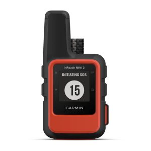
Don’t have any room left in your backpack? No problem. The inReach Mini can literally fit in the palm of your hand. Get weather updates, send messages, share your location, and send interactive SOS alerts anytime, anywhere, whenever you need.
Key Tech Specs:
Dimensions: 2.04″ x 3.90″ x 1.03″
Weight: 3.5oz
Battery Life:
Up to 90 hours at 10-minute tracking (default)
Up to 35 hours at 10-minute tracking with 1-second logging
Up to 24 days at 30-minute tracking power save mode
This super lightweight, rugged, global satellite messenger is the perfect companion for any adventure, even in the most extreme environments. It is battery-powered, lasting up to three weeks without a charge, and is Bluetooth® compatible, allowing for a full two-way experience wherever you are. The device can track and report position at any time interval from five seconds to 12 hours, offering flexibility and peace-of-mind in remote locations. And for the budget-conscious, it has pay-as-you-go satellite communications plans, so you’re only on the hook when you’re outside of cellular coverage.
Key Tech Specs:
Dimensions (L x W x H): 5.7″ x 3″ x 1.4″
Weight: 10.8 oz
You can send two-way messages using the handset or a dedicated app on your cell phone.
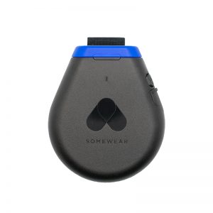
The Global Hotspot powers Somewear’s communications platform tailored for teams, whether for professional guiding operations or adventurous solo excursions. Engineered to keep teams connected in the most remote locations, it ensures that every user can share critical information, receive vital updates, and monitor each other’s position on the map.
The Somewear Global Hotspot provides peace of mind by ensuring that communication lines remain open, enhancing safety and operational efficiency in any environment.
Key Technical Specifications:
Dimensions (L x W x H): 76.2mm x 91.4mm x 20.3mm
Weight: 113.4g
Will last for over 10 days with 10-minute interval tracking
This is a full two-way global communications device and tracking system all in one. The YB3 can automatically send position information, allowing users to send and receive short messages from anywhere. All messaging and GPS information is stored in a simple online map, making staying in touch with family and friends a breeze. They can follow trip progress, send messages and texts all through one platform.
Key Tech Specs:
Dimensions: 144 x 76 x 36mm (plus antenna)
Weight: 305g
Battery Life: over 3,500 transmissions on a single charge
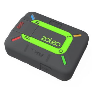
Affordable and easy to use, ZOLEO is the global messaging and safety solution that seamlessly transmits over cellular, satellite, and Wi-Fi networks using the lowest cost option available. ZOLEO works with users’ smartphones to provide two-way messaging, GPS location sharing, local weather forecasts, and advanced personal safety features like Progressive SOS alerting and Medical Assist with 24/7 monitoring and response. Additionally, ZOLEO provides users with a dedicated SMS number, making it easy for contacts to initiate messaging.
Rugged and compact, ZOLEO is perfect for remote workers and outdoor enthusiasts, offering unmatched peace of mind anywhere on Earth.
The maritime industry relies heavily upon a vessel’s ability to communicate while at sea. Whether it’s to report its position, conduct maritime operations, arrange for shore services, or even raise distress alerts, mariners need bespoke and reliable communications solutions. With over 70% of the planet covered by oceans and no mobile networks at sea, seafarers have only one reliable option if they want to communicate during voyages: satellite networks. Understanding what types of satellite networks are available, how they differ, and what is the optimal choice are key questions for modern mariners.
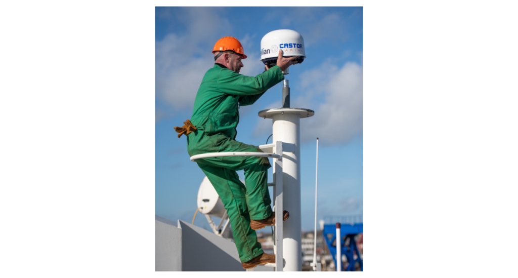
Intellian C700 install
Satellite Bands: A Primer
An increasingly common trend for ocean-going vessels is the adoption of hybrid connectivity solutions, which are a combination of different satellite networks working together to ensure consistent and reliable connectivity. These hybrid solutions take advantage of the benefits offered by each network to create a reliable service that meets the needs of ships’ crews while at sea. The most heavily used satellite bands for mariners are based on L-band (1 to 2 GHz), and either Ku-band (12-18 GHz) or Ka-band (26 to 40 GHz) radio frequencies.
Each frequency band has unique advantages and disadvantages; however, Ku and Ka share similar characteristics. Ku and Ka-bands are higher frequency bands that offer wide bandwidth and faster transfers, allowing more data-demanding applications both for ship’s business and crew welfare. However, Ku and Ka are more susceptible to loss of service due to inclement weather, line-of-sight blockages – particularly for service from geostationary satellites, smaller service areas and restrictions on usage in and around certain major ports.
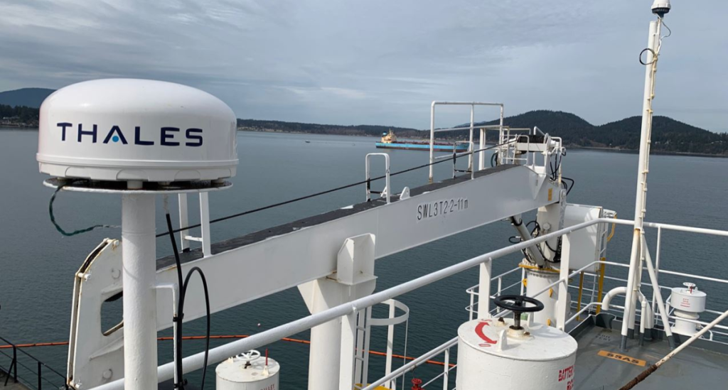
Thales VesseLINK 700
Being higher in frequency range means Ku and Ka-band services are delivered through shorter radio waves that can be more easily scattered due to rainfall and other atmospheric moisture. This can result in outright loss of connectivity, or severe service degradation for extended periods of time.
Line of sight blockages are a recurring challenge for these satellite systems, especially when considering the location of the satellites in orbit and position of the vessel at sea. Geostationary satellites, aligned with the Earth’s equator, orbit over 36,000 km from the earth and face increasing connectivity challenges the further north or south a vessel sails. In these cases, either the vessel’s superstructure, dockside buildings, and cranes surrounding a ship can block or reduce signals. This is different from some Low Earth Orbit (LEO) satellite networks that are only hundreds of kilometers from earth, amongst them, one of which – Iridium – provides truly global connectivity.
Cobham SAILOR 4300
Very small aperture terminal (VSAT) services can be further restricted by some national regulations, mandating that Ku or Ka-band antennas onboard must be disabled when either alongside or near to shore to prevent local interference to land-based radio systems. These additional issues must be factored in when planning a fleet hybrid communications solution.
Connectivity Companionship
Despite the advantages that Ka and Ku-band present, there is a clear need for a companion service resilient to their limitations for safety, compliance, and a ship’s business continuity. This makes L-band satellite networks a critical component of any hybrid connectivity solution. As L-band is lower in frequency compared to Ka and Ku-band, its wavelengths are longer, enabling continued connectivity during inclement weather. It also works at the world’s top ports, where other services may be restricted, blocked or otherwise unavailable. And, if the right network is chosen, provides service everywhere on the planet. The trade-off for vessels is that L-band cannot match the broadband speeds of Ka and Ku-band systems. However, its dependability and reliability are vastly superior. In fact, L-band is used to transmit groundbreaking scientific data and videos from hurricanes at sea.
L-band remains the primary network for maritime safety and security services, including distress alerting or notifying authorities of a pirate attack. The International Maritime Organization (IMO) mandates that all Safety of Life at Sea (SOLAS)-class vessels have L-band-based regulatory equipment and services onboard.
Iridium’s Maritime Bona Fides
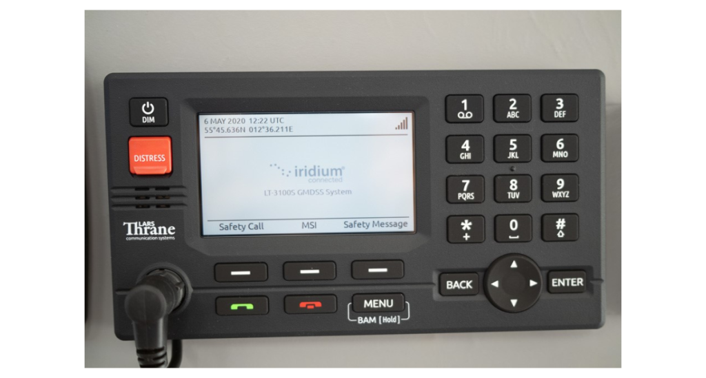
Iridium has a long history of providing IMO-certified and regulated solutions for the challenges that mariners experience. In 2020, the Iridium® Global Maritime Distress and Safety Service (GMDSS) was launched— providing the first truly global, satellite-based maritime distress system with the Lars Thrane LT-3100S system. Iridium GMDSS integrates Long-Range Identification and Tracking (LRIT) and Ship Security Alert System (SSAS) regulatory services into a single satellite terminal, and is the only satellite network that covers the entire planet, from pole-to-pole. A year earlier, in 2019, Iridium launched its Iridium Certus® service, which swiftly established itself as the companion service of choice for the modern maritime industry.
The Lars Thrane LT-3100S GMDSS System
Through its ecosystem of globally-recognized partners, there is a suite of Iridium Certus terminals built for ships at sea, such as the Thales VesseLINK 700 and 200, Intellian C700 and C200M, Cobham SAILOR 4300 and Lars Thrane LT-4200. These ruggedized, weather-resilient terminals with solid-state antennas operate on the Iridium Certus 700 specialty broadband service and give mariners the confidence they can reliably stay connected, anywhere in the world. In the fourth quarter of 2024, Iridium expects to launch Iridium GMDSS services on Iridium Certus across a range of satellite terminals. As per existing Iridium GMDSS services, Iridium Certus GMDSS terminals will be all-in-one—combining GMDSS, LRIT, and SSAS services plus companion communications for a vessel.
TL;DR
As discussed, each frequency band has both advantages and disadvantages. The maritime industry understands that the modern business of shipping relies upon well-connected vessels regardless of their location or weather. Connected vessels rely upon high-speed access provided by Ku and Ka-band for both business operations and crew welfare. However, a more resilient and reliable link is needed for critical operations, safety and security. L-band is the de-facto maritime standard for satellite communications, and the logical and dependable companion to Ku and Ka-band systems. Iridium is that critical companion link enabling reliable connectivity globally for the maritime industry.
Learn More
Go here for all things Iridium maritime safety and security and contact us.
Learn how the Iridium Network operates and its advantages in this animation.
Recently, Iridium supported the UK Antarctic Heritage Trust, an organization dedicated to preserving historic sites and monuments throughout the Antarctic Peninsula. In this post, guest blogger Lisa Ford, General Assistant at Port Lockroy, explains how the Iridium GO! exec® played an instrumental role in their conservation efforts.
Life at Port Lockroy in Antarctica is busy and full of all sorts of challenges but so enjoyable. There has been a lot of heritage conservation underway this year as well as the team going on and off the island most days to do pop-up shops for passengers on ships and yachts and doing presentations about the history of Port Lockroy and life on base. Work on the museum has been progressing well, and the roof beam has been repaired after it was damaged with the heavy snow on the roof last season.
Communications with the UK and ships nearby is key to enabling us to be here. Bridie Martin-West, our Base Leader, sends confirmation each day back to the UK letting the team know all is well on the island. We have been testing the various communication options, including our Iridium GO! exec equipment to enable us to contact the UK and emergency health care backup options.
We have been making sure we have time to practise our first aid emergency training skills learnt before we left the UK. We recently completed an emergency scenario, testing our skills and ensuring we all know how to use the communication equipment. All went very well. Of course, we hope we will not have to deal with any emergencies on the island.
A UK Antarctic Heritage Trust staffer at Port Lockroy uses the Iridium GO! exec to make a phone call.
Whilst we are busy, the gentoo penguins have chicks and all are growing fast. We will be on our way home in March, leaving this beautiful pristine part of the world for the gentoo chicks to finish moulting and have their adult feathers ready for their departure and eventual return next summer when the new Port Lockroy team arrives.
Thank you to all at Iridium for supporting us in this remote and unique part of the world!
MCLEAN, VA., March 18, 2024 – Iridium Communications Inc. (Nasdaq: IRDM) today announced that John McNiff has joined Iridium as Vice President and General Manager overseeing Iridium’s Space Development Agency (SDA) support, effective February 5, 2024.
In this new role, John is providing leadership and strategy for Iridium’s Space Development Agency (SDA)-related business, as it establishes the ground Operations and Integration (O&I) segment for Tranche 1 of the Proliferated Warfighter Space Architecture (PWSA). The core operations and integration functions include enterprise management, network management, mission management, payload data management, and constellation monitoring that spans the ground, link, space, and user segments of the architecture.
John joins Iridium from Microsoft Federal where he led the Intelligence Operating Unit focused on delivery of Microsoft products and services to its key national security customer vertical. With more than 30 years of experience, John has held numerous executive positions within the federal contracting industry. He spent 16 years at Northrop Grumman, holding senior executive management positions in program management, P&L operations, business development, and corporate strategy. John began his career as an engineer and product manager for commercial satellite and cellular telecommunication companies including GTE and Iridium.
“John brings a great deal of experience and expertise that will help turbocharge Iridium’s SDA operations,” said Scott Scheimreif, executive vice president of government programs, Iridium. “After having previously worked at Iridium as a product manager years ago, we’re glad his career has come full circle with him re-joining our team in this new role. We look forward to his leadership in driving smooth SDA operations and continued success.”
The Iridium team is working to operate and maintain state-of-the-art, commercial-like operations centers and ground entry points, and lead ground-to-space integration efforts. To support these growing initiatives, Iridium is continuing to hire for a variety of new roles.
About Iridium Communications Inc.
Iridium® is the only mobile voice and data satellite communications network that spans the entire globe. Iridium enables connections between people, organizations and assets to and from anywhere, in real time. Together with its ecosystem of partner companies, Iridium delivers an innovative and rich portfolio of reliable solutions for markets that require truly global communications. In 2019, the company completed a generational upgrade of its satellite network and launched its new specialty broadband service, Iridium Certus®. Iridium Communications Inc. is headquartered in McLean, Va., U.S.A., and its common stock trades on the Nasdaq Global Select Market under the ticker symbol IRDM. For more information about Iridium products, services and partner solutions, visit www.iridium.com.
Press Contact:
Jordan Hassin
Iridium Communications Inc. Jordan.Hassin@iridium.com
+1 (703) 287-7421
Investor Contact:
Kenneth Levy
Iridium Communications Inc. Ken.Levy@Iridium.com
+1 (703) 287-7570
Satellite networks can play a critical role in keeping the world’s rail transport and delivery system safe and successful.
Rail systems are key to the global economy and can contribute significantly to a country’s gross domestic product (GDP). For example, in the United States, an average of 1.6 billion tons (or 1.45 billion metric tons) of cargo is freighted on railroads every year—according to the Association of American Railroads (AAR). It’s no wonder trains need to keep moving with as few delays as possible.
To keep trains safe, on track, and able to transport people and goods on time, railway operators must have access to a reliable communications system that works everywhere. While many rail operators rely on private or cellular networks to connect centralized command and control systems to improve railroad operations and safety, there remain thousands of miles of “dark territory”: areas without ground-based infrastructure (and therefore unsupported by terrestrial communications solutions). Having a resilient communications infrastructure can help to ensure smooth operations by keeping conductors in contact with other trains and operators, enabling real-time machine health monitoring, and giving operators the ability to run diagnostic reports as needed. All these capabilities are vital to ensuring a successful route and keeping railways as safe as possible—preventing disasters like train-to-train collisions and overspeed derailments.
How is this possible? Equipping trains with reliable, global satellite communications (SATCOM) can establish complete network coverage. Let’s find out how…
What is Positive Train Control?
Positive Train Control (PTC) includes protocols and procedures implemented within a train’s operating system and designed to prevent the most dangerous and life-threatening situations while on track. According to the U.S. Department of Transportation, several of the most common occurrences include train-to-train collisions, incorrect train maneuvers due to switches being left in improper positions, overspeed derailments, and incursions into established work zones. Equipping a train’s PTC with SATCOM technology helps to ensure that no matter where the train travels, a reliable connection will be available and important data points will not be missed.
Getting From Point A To Point B: Track Sensors & Crew Communications
Satellite networks can enable more than just a train’s PTC system. Track sensors and conductor communications, two of the most critical components to train operations, can utilize satellite networks to transmit critical data and enable onboard communications for crew safety. Track sensors enabled by satellite networks can transmit vital safety information such as remote rail condition monitoring, including temperature and obstruction detection to warn of potential hazards. Sensors can also be deployed in flood and mudslide-prone areas to convey track condition changes that can prevent accidents, improving safety and reducing operational costs.
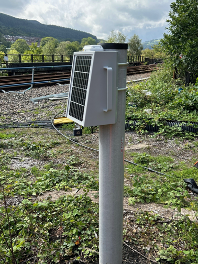
Radio Data Networks track-side wireless satellite gateway. Image credit: Radio Data Networks Limited.
For example, Radio Data Network’s battery-powered Rail Monitoring Solution, enabled by Iridium’s satellite network, captures real-time data of a track’s temperature and can be installed anywhere. This gives train conductors and rail control centers forewarning of any potential rail buckling due to extremely warm temperatures, or ice due to exceedingly cold temperatures, anywhere along the tracks. As important as all this sounds, the information being collected is only useful if it is quickly delivered to the correct people. With many sensors placed alongside tracks in areas located far beyond cellular coverage, satellite networks are the key ingredient to ensuring this important safety capability stays connected and information gets where it needs to go.
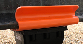
Radio Data Networks sensor/transmitter assembly mounted to the foot of the rail on an insulator clip. Image credit: Radio Data Networks Limited.
How Does SATCOM Provide Trains With Complete Network Coverage?
It may come as a surprise, but only about 15% of the world has cellular coverage. This means rail networks traverse a lot of uncovered areas. When a train is out of cellular coverage, satellite communications fills the gap—serving as the link between a train’s PTC system, the conductor’s communications with railway stations, remote track sensors, and the operator’s command center.
Satellite networks provide connectivity in areas of the world that cellular networks don’t view as worthy of significant infrastructure investments. Whether it’s a cellular network or a private rail system network, the costs to build and maintain these networks are difficult to justify relative to the costs associated with SATCOM.
SATCOM terminals are increasingly affordable, available commercially off-the-shelf, and are simple to install on a train. Iridium, for example, offers low-latency, weather-resilient global connectivity via its crosslinked Low Earth Orbit (LEO) satellite constellation.
Trains equipped with Iridium Connected™ PTC technology and crew communications systems can stay connected along their remote routes, giving operators and technicians real-time information about the assets they are delivering. Iridium Connected track sensors offer a weather-resilient, small-form-factor solution for receiving critical safety data that can be discreetly placed and doesn’t suffer from the look-angle challenges in mountainous or high-latitude regions faced by geostationary networks. Additionally, rail applications that run over Iridium Certus® offer all the mentioned benefits of Iridium’s network in a variety of speed class options. User requirements can be tailored to their data needs.
Working in the maritime industry is not for the faint of heart. Commercial shipping and fishing vessel crews are vulnerable to natural elements, the isolation of the open seas, and—in some regions—the possibility of piracy incidents. The Iridium® Global Maritime Distress and Safety System (GMDSS) was created as a safety mechanism for these threats, serving as a communications lifeline for vessels in distress.
Kyle Hurst, Iridium’s Director of Maritime Safety and Security Services, recently joined Digital Ship, one of the largest and most influential maritime publications, to discuss several service developments made to Iridium GMDSS and how they’re benefiting maritime communications and crew safety across the globe.
The Three “Seas”: Iridium GMDSS Benefits
Traversing the open seas requires a truly global network, and with its ecosystem of world-class partners, Iridium maritime safety equipment is designed to keep fleets safe and connected, no matter where they are in the world.
Hurst describes the key benefits of the Iridium GMDSS as the “three Cs” (or “Three Seas”—if you’re into puns):
Cost
“Having improved technology at a lower cost helps maritime safety in general,” Hurst notes. A lower cost means higher accessibility so more fleets can be equipped with Iridium GMDSS. The inaugural Iridium Conntected™ GMDSS terminal, the Lars Thrane LT-3100S, supplies all satellite GMDSS services with Iridium’s additional features for around a quarter of the cost of competing equipment requirements.
Iridium GMDSS is the only system with safety voice capabilities.
“The phone call is key,” Hurst explains. “Knowing the nature of the distress, how many people are on board, and what the crew is doing allows the Rescue Coordination Center [RCC] to understand more about what’s going on and design an appropriate response.” Learn more about RCCs.
Iridium GMDSS also connects crew members to medical professionals for immediate assistance in emergencies.
Charting A New Path
Hurst described Iridium’s recent maritime performance, noting the company has seen “solid growth in activations and installation over the first three quarters of 2023, demand well above 2022 numbers.”
Around 20% of vessels have installed two Iridium GMDSS terminals for built-in voice redundancy.
“We have seen a lot of shipping companies moving toward Iridium GMDSS,” Hurst said, describing a significant shift from passive to active implementation strategies, meaning more companies are switching working terminals for Iridium GMDSS rather than just replacing terminals on failure.
With the wind of these successes in its sails, Iridium is gearing up for the anticipated release of GMDSS over Iridium Certus® in late 2024.
“In my view, you’ll have the fastest L-band broadband terminal with the most technologically advanced GMDSS all combined in one package,” according to Hurst.
Iridium has also launched its GMDSS Academy—a comprehensive curriculum designed for maritime academies and students. The three-module training includes up-to-date resources on the Iridium network and its evolving performance, Iridium GMDSS service capabilities, the latest equipment developments, and insights on how Iridium GMDSS can make a critical difference in maritime safety operations.
By Michelle Houchins, Iridium Diversity & Inclusion Council member and Engineer
Every March, we celebrate Women’s History Month and International Women’s Day. These celebrations are an opportunity to not only honor the extraordinary achievements of women, but to recognize the work that still needs to be done to achieve gender equality.
International Women’s Day traces its roots back to 1908 in New York City, where female factory workers united together to protest poor working conditions. The following year, the National Socialist Party of America established the first National Women’s Day to honor these courageous factory workers. It wasn’t until 1917, when women were granted the right to vote by the Provisional Government of Russia, that International Women’s Day became a national holiday celebrated on March 8. Over the years as the international women’s movement grew, more countries began celebrating International Women’s Day. In 1977, the United Nations officially recognized International Women’s Day as a holiday.
The story of Women’s History Month begins in the city of Santa Rosa, California. In 1978, the women of Santa Rosa organized the very first Women’s History Week. Discontented with the lack of women’s history in K-12 curriculum, these women designated the week of March 8 to highlight the contributions of women in American history. The week was full of special activities in schools, a nationwide “Real Woman” essay contest, and even a celebratory parade held in downtown Santa Rosa, California. The following year, other communities followed suit and put on their own Women’s History Week festivities. In 1980, President Jimmy Carter proclaimed the week of March 8 as National Women’s History Week. When Congress passed Public Law 100-9 in 1987, March finally became designated as Women’s History Month.