The Best Satellite Messengers For Your Adventures
With summer approaching, your pals at Iridium have created this handy, carefully-curated list of the best personal satellite messengers. Whether you’re climbing, biking, distance running, kayaking, backcountry camping, or just chillaxin’ in the deep woods, this suite of Iridium Connected™ solutions ensures you’ll maintain communications no matter how far you venture off the grid. Every product on this list communicates over the Iridium satellite network.
Why are Iridium Connected Satellite Messengers the Best?
They’re Reliable
Our network uses L-band satellite spectrum–giving end users a weather-resilient experience, which is invaluable for the outdoor, extreme sports, and adventure traveler communities. Additionally, the network is located in Low Earth Orbit (LEO), delivering a low-latency (or minimal delay) two-way communications experience.
They Have Unmatched Coverage
Every Iridium satellite is connected to its neighbors by crosslinks, creating a coverage web around the entire planet. Iridium remains the only satellite network that offers truly global coverage.
The Battery Life
The devices below can hold a charge for long stretches of time–with many providing hundreds of hours per charge.
Cost
When people think satellite communications, they think big bucks. However, because Iridium satellite messengers are small, lightweight, and have comparatively low power requirements, they are often more cost-effective than competing products with bigger antennas and greater power needs. There are also customized subscription plans available based on data needs to help manage budgets without having to sacrifice service quality.
And Now, the Best Satellite Messengers (in Alphabetical Order)
Bivy Stick
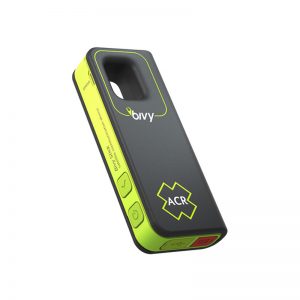
Small, mighty, and looking snazzy in lime green, the Bivy Stick provides a combination of convenience and safety. The device is perfect for any off-grid activity, enabling two-way connectivity for sending and receiving texts, emails, and weather reports. It also supports SOS monitoring and GPS capabilities. The device can be easily carried or mounted, with many different mounting configurations, making it an ideal on-the-go device to bring anywhere.
Key Tech Specs:
- Dimensions (L x W x H): 111.5mm x 45.0mm x 20.5mm
- Weight: 100g
- Battery Life: 120 hours
Garmin – inReach Explorer®+
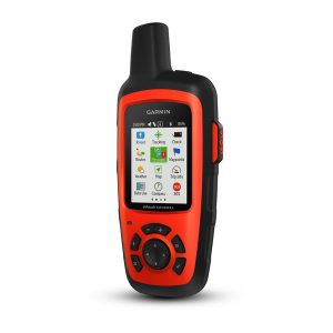
This satellite messenger packs a lot of capabilities into a diminutive frame. It is a rugged, handheld satellite communicator with two-way text messaging, 24/7 interactive SOS search and rescue monitoring (when triggered), and location sharing and tracking capabilities. It is also compatible with mobile devices using the Earthmate® app that gives access to downloadable maps, U.S. NOAA charts, color aerial images, and more. The device includes pre-loaded DeLorme® TOPO maps with GPS routing, a digital compass, barometric altimeter, and accelerometer.
Key Tech Specs:
- Dimensions (L x W x H): 2.7″ x 6.5″ x 1.5″ (6.8 x 16.4 x 3.8 cm)
- Weight: 7.5oz (213g)
- Battery Life:
- Up to 100 hours at 10-minute tracking mode (default)
- Up to 75 hours at 10-minute tracking with 1-second logging
- Up to 30 days at the 30-minute interval power save mode
- Up to 3 years when powered off
Garmin – inReach® Messenger
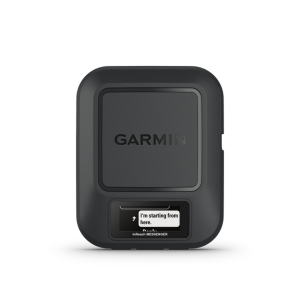
Text from anywhere with this tough, tiny and piece of tech. Equipped with GPS, interactive SOS alerts, location sharing, and group messaging, users can communicate easily with loved ones (or even liked ones, or even “it’s complicated” ones) and access help if needed, no matter where they travel. The device can switch between cellular and satellite connectivity as needed and has 28 days of battery life between charges (see more details below), so nowhere is too remote and no trip is too long for this device.
Key Tech Specs:
- Dimensions: 3.1″ x 2.5″ x 0.9″ ( 7.8 x 6.4 x 2.3 cm)
- Weight: 4 oz (113.9 g)
- Battery Life:
- Up to 28 days with a message or location sent every 10 minutes with full sky view
- Up to 14 days with moderate tree cover
- Up to 6 days with a message or location sent every 2 minutes with full sky view
- Up to 3 days with moderate tree cover
- Up to 46 days with a message or location sent every 30 minutes with full sky view
- Up to 23 days with moderate tree cover
- Up to 1 year when powered off
Garmin – inReach® Mini
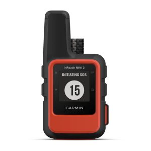
Don’t have any room left in your backpack? No problem. The inReach Mini can literally fit in the palm of your hand. Get weather updates, send messages, share your location, and send interactive SOS alerts anytime, anywhere, whenever you need.
Key Tech Specs:
- Dimensions: 2.04″ x 3.90″ x 1.03″
- Weight: 3.5oz
- Battery Life:
- Up to 90 hours at 10-minute tracking (default)
- Up to 35 hours at 10-minute tracking with 1-second logging
- Up to 24 days at 30-minute tracking power save mode
- Up to 1 year when powered off
RockSTAR
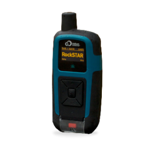
This super lightweight, rugged, global satellite messenger is the perfect companion for any adventure, even in the most extreme environments. It is battery-powered, lasting up to three weeks without a charge, and is Bluetooth® compatible, allowing for a full two-way experience wherever you are. The device can track and report position at any time interval from five seconds to 12 hours, offering flexibility and peace-of-mind in remote locations. And for the budget-conscious, it has pay-as-you-go satellite communications plans, so you’re only on the hook when you’re outside of cellular coverage.
Key Tech Specs:
- Dimensions (L x W x H): 5.7″ x 3″ x 1.4″
- Weight: 10.8 oz
- You can send two-way messages using the handset or a dedicated app on your cell phone.
- Battery life varies according to usage patterns:
- 12 months transmitting once per day
- 3 months transmitting once per hour
- 3 weeks transmitting every 15 minutes.
Somewear Global Hotspot
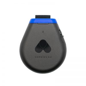
The Global Hotspot powers Somewear’s communications platform tailored for teams, whether for professional guiding operations or adventurous solo excursions. Engineered to keep teams connected in the most remote locations, it ensures that every user can share critical information, receive vital updates, and monitor each other’s position on the map.
The Somewear Global Hotspot provides peace of mind by ensuring that communication lines remain open, enhancing safety and operational efficiency in any environment.
Key Technical Specifications:
- Dimensions (L x W x H): 76.2mm x 91.4mm x 20.3mm
- Weight: 113.4g
- Will last for over 10 days with 10-minute interval tracking
YB3
![]()
This is a full two-way global communications device and tracking system all in one. The YB3 can automatically send position information, allowing users to send and receive short messages from anywhere. All messaging and GPS information is stored in a simple online map, making staying in touch with family and friends a breeze. They can follow trip progress, send messages and texts all through one platform.
Key Tech Specs:
- Dimensions: 144 x 76 x 36mm (plus antenna)
- Weight: 305g
- Battery Life: over 3,500 transmissions on a single charge
ZOLEO
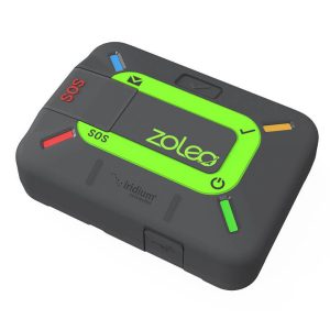
Affordable and easy to use, ZOLEO is the global messaging and safety solution that seamlessly transmits over cellular, satellite, and Wi-Fi networks using the lowest cost option available. ZOLEO works with users’ smartphones to provide two-way messaging, GPS location sharing, local weather forecasts, and advanced personal safety features like Progressive SOS alerting and Medical Assist with 24/7 monitoring and response. Additionally, ZOLEO provides users with a dedicated SMS number, making it easy for contacts to initiate messaging.
Rugged and compact, ZOLEO is perfect for remote workers and outdoor enthusiasts, offering unmatched peace of mind anywhere on Earth.
Key Tech Specs:
- Dimensions (L x W x H): 90.9mm x 66.0mm x 26.9mm
- Weight: 150g
- Battery life: 200+ hours