Developer Spotlight Series: OCENS’ Grib Explorer Plus, FLYCAST, QWIP & AWARe for Iridium GO!® Enable Safe & Smart Traveling
Effective and smart communications is a key factor in successful explorations, missions, expeditions and any kind of travel at sea, in the air or in remote areas of the globe. Within the Iridium GO! application developer portfolio, OCENS provides numerous ways to stay connected and informed while exploring remote lands, jet-setting on your personal aircraft or sailing the high seas. All OCENS applications hit home with the essence of Iridium GO! users – people who are off the grid and need reliable communications and helpful information to stay connected to the outside world, and safe during their journey.
Grib Explorer Plus for Iridium GO!
What if you could receive helpful visual weather data images while travelling at sea? Look no further. Grib Explorer Plus melds Grib weather and ocean data into detailed images carrying detailed insights into the environment around you. With Grib Explorer Plus, any at-sea user can access three-dimensional imagery of their environment to help plan travel routes and avoid hazardous weather conditions. From weather forecasts to wave and swell data, the boating and surfing community is covered.
FLYCAST for Iridium GO!
 Flycast is an application for the aviation market that provides flight-specific aviation weather forecasts and insights, up to twelve hours ahead, for any location on earth. Pilots and crew members simply type in their ICAO code, hit send and moments later TAF and METAR reports are returned, providing a sense of security in knowing valuable weather information while miles up in the sky. From air temperature to dew point temperature, visibility and cloud coverage percentages, FLYCAST and Iridium GO! provides the quick and necessary information to prepare pilots for any turbulence. Connecting with the Iridium GO! leaves no area of the earth uncovered, enabling safe and smart flying.
News & Sports for Iridium GO!
 Another OCENS application, News & Sports compiles information on important news stories, stock updates, sports and more directly on to your Iridium GO! device, without breaking the bank. QWIP keeps you connected to the outside world, while you are off working or traveling in remote areas, where traditional modes of communication are not an option. For Apple iOS and Android, PC.
AWARe for Iridium GO!
The newest application by OCENS, called AWARe, is a game changer. Instead of the customer activating their Iridium GO! to request a weather forecast, the application is proactive and will alert the end user of severe weather or natural hazards in their vicinity. The AWARe service can monitor the location of an Iridium GO! device through its tracking and position information, and directly send alerts of natural hazards around or near the customer, in real time, in addition to forecasted reports. From high winds or tornadoes, to waves or tsunamis, hurricanes or earthquakes, or wildfires and blizzards, AWARe can alert you when danger is heading your way and act as your weather eyes and ears.
For example, imagine you are a hiker in the Moab, trekking through remote and rough terrain, and there are reports of flash flooding. AWARe can automatically alert you to the danger in your vicinity, by letting you know of the threat and how to mitigate your exposure.
For more information about OCENS, please visit – http://www.ocens.com/Default.aspx
For more information about Iridium GO!, please visit – https://www.iridium.com/products/Iridium-GO.aspx
Stay tuned for our next Developer Spotlight, highlighting applications for Iridium GO! from two10Degrees!
It’s impossible to anticipate emergency situations before embarking on an adventure, but it’s critical to always be prepared to handle one. In the instance of Sergey Ananov, a friend of Michael Farih’s as well as the rest of the Three North Poles Expedition group, it wasn’t just about taking the proper precautions and having an emergency plan – it also meant having the best technology to ensure his safety.
 Sergey was attempting to fly around the world in an R22 helicopter. His trip would start from Moscow and he’d fly east across the entirety of Russia. He’d then fly into North America, and zig-zag between the Gulf of Mexico and Canada – a requirement for collecting the necessary miles for an around-the-world trip. He’d eventually fly across the north Atlantic Ocean, over Greenland and across parts of Europe, before returning to Moscow.
For those unfamiliar with Russia, there aren’t too many noticeable landmarks when traveling through the uninhabited parts of the country.
With limited visual cues, it’s easy to get lost if you don’t have the right tools. In fact, Sergey quickly identified his initial equipment selection to be unreliable, causing him to get lost a few times crossing Siberia and far-east Russia. As previously indicated, with finite flying time between refuels, every minute can make the difference between a successful journey and disaster. Upon reaching the eastern part of Russia, he made a critical decision to pick up a DeLorme inReach SE before continuing his journey – a move that may have ultimately saved his life.
 With the device now in hand, Sergey used the inReach, enabled by the Iridium global network, to share his coordinates with Michael, who was back in Moscow. Sergey set the inReach to provide coordinates every two minutes initially, but eventually switched it to every 10 minutes. However, Michael recommended reverting back to a two-minute interval before crossing oceans, as the granularity of the data would be more useful in the event of an emergency. Sergey obliged. “I’ve crossed oceans before during my own travels and have also followed my friends’ trans-ocean expeditions, so I know how important it is to know your exact location in case of an incident that requires a search and rescue,” said Michael.
As Sergey reached the north Atlantic Ocean between Canada and Greenland, his Iridium-enabled devices worked flawlessly. He didn’t anticipate one other key piece of technology to fail though – his helicopter. As one of the drive belts failed in Sergey’s helicopter, he was forced to descend toward the icy water below. With limited time to act, Sergey managed to perform a controlled ditch into the ocean and climb onto a floating piece of ice. Although he was not injured during the ditch, he was not out of the woods yet, as he was in a frigid environment with no means of communication.
Thankfully, the timing of the inReach signal providing Sergey’s coordinates to Michael was in the last seconds before the helicopter sank, reporting zeroes for both his altitude and speed. As soon as Michael received the transmission and realized the gravity of the situation, he immediately alerted the Canadian coast guard to launch an emergency search and rescue.
Had Sergey been able to retrieve the inReach, he could’ve provided continuous, real-time coordinates of his location and also receive messages from the rescue team, but it was lost with the helicopter. Still, Sergey trusted the tracking capabilities of his inReach and was confident that a rescue operation was underway, but he was still in the middle of nowhere and he wasn’t alone. As he floated on that piece of ice, a curious polar bear began to approach his location. Fearing for his safety, Sergey attempted to scare off the polar bear. He was successful in doing so at that moment, providing some momentary relief, but that wouldn’t be the only time that a polar bear visited him. Luckily, he was once again able to deter the other polar bear during the second encounter.
“As a basic rule, polar bears find stranded artic travelers sooner than the rescue teams,” said Sergey. “I was very lucky to find common language with them, or maybe they just weren’t that hungry.”
Upon leaving their base for the rescue attempt, the Canadian coast guard experienced some harsh weather that severely limited their vision. With little to no visibility, the rescue team had to rely heavily on the last coordinates from the inReach and hope that Sergey hadn’t drifted too far. A dramatic 38 hours later, the coast guard was able to find and rescue Sergey – thanks primarily to the inReach providing the last-second coordinates of his location in a vast sea of ice.

“I know that my inReach was reliable, and I was confident that it had sent my location during its last signal,” said Sergey. “Five hours after the accident, a rescue aircraft flew overhead. I tried to get its attention with a flare, but the aircraft was unable to see me due to the fog. But I was at least sure that a rescue team knew my coordinates – and that’s all thanks to Iridium technology. I just had to stay alive in the harsh conditions and be ready to send a visual distress signal when needed.”
Sergey, along with members of the Three North Poles Expedition, are just a small sample of adventurers and professionals that rely on Iridium devices to remain connected and safe while traveling. As the only network offering pole-to-pole connectivity and communication, Iridium helps provide the peace of mind adventurers like Sergey and Michael need to embark on these types of expeditions, and ultimately make the world more accessible.
While it may seem like a given, if you’re flying a helicopter and it runs out of fuel, the engine immediately shuts off. This poses a serious problem when flying long distances in remote locations and over icy waters – say, to and from the three North Poles (geographic, magnetic and the pole of inaccessibility), for example. This posed one of the largest challenges facing Evgeny Kabanov, Michael Farih, and the other members of the Three North Poles Expedition.
In some cases, explorers can reach agreements with international services or aviation organizations to provide refueling accommodations. However, in the case of the Three North Poles Expedition, busy schedules, limited resources, and language barriers prevented the pilots from reaching an agreement with the Norwegian coast guard.
“We had to fly about 715 nautical miles from Svalbard to the Barneo ice base, and that was far beyond our fuel range. That presented us with two options: either make multiple trips and shuttle the fuel ourselves, or find some transport to carry our barrels as far north as possible” said Evgeny. “After weeks of negotiations with various providers, we reached an agreement with a Russian coal company operating in Svalbard that would provide one of their large Mi-8 helicopters that could be used to cargo our fuel.”

The Mi-8 took the extra fuel, leaving a few minutes before the expedition group, and delivered it about 185 miles north of Longyaerbyen, leaving it on a large ice float. As the Mi-8 was a few minutes ahead of the group, the captain then relayed the coordinates to them, so they could easily locate the barrels.
Although the ice float was large enough to hold multiple helicopters and the fuel tanks, it was still drifting unpredictably in open water – meaning there was no guarantee that it would remain in the same location during the return trip days later.
The group needed a reliable way to track its location, so they opted to leave behind a DeLorme inReach SE with the fuel tanks and set it to emit a locator signal every four hours. Using the GPS capabilities of the inReach, the expedition’s ground team in Moscow could then relay the changing coordinates of the “fuel depot” to the team, which they would receive on their smartphones, thanks to their Iridium GO!®.
Iridium® devices are designed to be ruggedized and withstand the elements, but not everyone gets the actual opportunity to push that limit. For the pilots, they didn’t fear any malfunction caused by the cold, as Michael had personally tested an Iridium GO! by leaving it in the helicopter canopy overnight when temperatures hit -28º Celsius*.
The team safely arrived at their destinations and achieved their goal of visiting all three North Poles, but now came the tricky part – refueling and returning home. After many hours logged already on their return flight, they realized that they were reaching the bottom of their fuel tanks and only had about an hour of flight time remaining. To make matters worse, the visibility was poor that day, making it even more difficult to visually confirm the location of the fuel tanks.
Although Evgeny and Michael were using Iridium GO! to receive the fuel tank coordinates from the ground team in Moscow, they had set the tracking interval on the inReach to only emit a signal once every four hours to extend the device’s battery life. Within those signal intervals, the ice float could change direction and floating speed, making it even more difficult to track. With time and conditions working against them, the pilots needed to find their fuel quickly or risk going down in icy waters.
Luckily, the timing and accuracy of the inReach’s last signal correctly provided the ground crew with the location of the fuel tanks. With the Iridium GO!, the coordinates were provided to the pilots. Without the Iridium network, locating the tanks would have been nearly impossible, as the ice float had moved more than 42 kilometers from its initial position! With their helicopters successfully refueled, the group made it safely to the Svalbard airport, and eventually back to Moscow.
“When planning the expedition, we discussed different solutions for finding our fuel depot on the way back – radio beacon, marking the snow with a bright color, using a red helium-filled balloon. After some discussion, we decided to use the DeLorme inReach SE,” said Michael. “On the day we returned, the weather conditions were pretty poor, limiting our horizontal visibility to about 3 kilometers and our cloud base to about 200 feet. Without the inReach, we couldn’t find our fuel in those conditions, especially since it had moved more than 40 kilometers from its initial position.”

Iridium has proven to offer effective technology for keeping adventurers connected – no matter where they venture – and sometimes, that connectivity also proves to be lifesaving. Stay tuned for tomorrow’s post that highlights how Iridium helps simplify the “search” in “search and rescue.”
* We’re pleased Michael’s Iridium GO! handled these extreme conditions, but please note, when planning your own Arctic expedition, that this temperature is outside the Iridium GO!’s performance specification.
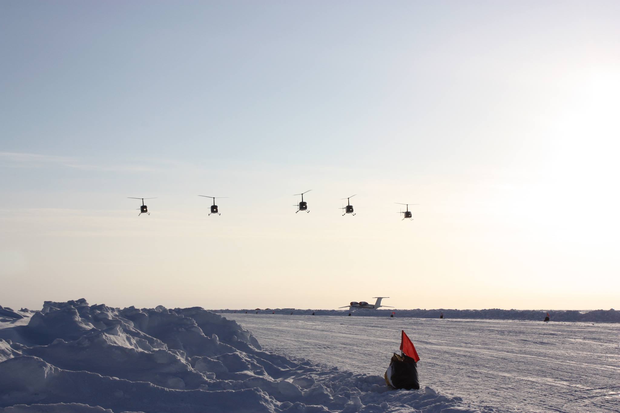
A helicopter expedition to the three North Poles (geographic, magnetic, and the northern pole of inaccessibility) – an incredible adventure or near-impossible feat? Depends who you ask. For Evgeny Kabanov and Michael Farih of Moscow, Russia, it was an opportunity to make history while pushing the limits of aviation.


As members of the Three North Poles Expedition, the plan was for the two of them to join six other experienced helicopter pilots in an attempt to visit all three North Poles in a single expedition, setting a world record in the process. Over the course of ten days, the group would leave from Moscow, travel to Svalbard, Norway, then onto the temporary ice base Barneo, and eventually hit the poles – visiting all three in one-day.
Traveling in four Robinson R66 helicopters, the pilots challenged the preconceptions and general practices of helicopter travel in remote locations. Prior to the expedition, it was not known whether light helicopters could fly at such low temperatures with sudden weather changes. Further, in the event of an emergency, there would be no help geographically available within a 1,000 kilometer radius, and it would be even more difficult to request assistance as the group traveled outside the range of traditional cellular and data service.
Considering the harsh conditions, the expedition required very careful preparation. Knowing this, the group brought along a variety of Iridium devices such as the Iridium 9555 handset and docking station, Iridium GO! ®, and the DeLorme inReach SE. They knew that they could trust Iridium, the only company offering pole-to-pole connectivity, to provide reliable, global connectivity to access valuable information and keep them safe while traveling off the grid. Evgeny and Michael were especially fond of Iridium GO!, as it added an extra layer of convenience and flexibility by letting the pilots use their own smartphones to access voice and data services, rather than using an unfamiliar device. This capability is crucial for the pilots who must maintain focus on the helicopter controls, and don’t have much time to figure out a new device or interface when communicating with the other pilots or checking coordinates.
“While the docking station for the Iridium 9575 is good if you fly the same aircraft, Iridium GO! is the ideal solution if you change helicopters – as I often do during different expeditions,” said Michael. “Iridium GO! can be installed and removed in seconds, it connects to your pilot’s headset via Bluetooth or your smartphone via Wi-Fi, and it has a solid battery so you can remove it from your cockpit and take it anywhere. The DeLorme inReach SE is also a superior solution for tracking and texting as well, as it works in high latitudes without service disruptions.”
With the trip mostly planned and the proper devices equipped, the only remaining detail was refueling. It’s about 700 nautical miles to the North Poles, which far exceeds the range for a flight-acceptable amount of auxiliary fuel. After all, these are small aircraft, so the pilots don’t want to exceed weight limits and jeopardize their flight. So then how do you coordinate refueling in a location beyond the reach of civilization?
Be sure to come back tomorrow to learn how Evgeny and Michael used their wits (and Iridium devices) to refuel their helicopters and support their potentially record-breaking expedition.
 Another OCENS application, News & Sports compiles information on important news stories, stock updates, sports and more directly on to your Iridium GO! device, without breaking the bank. QWIP keeps you connected to the outside world, while you are off working or traveling in remote areas, where traditional modes of communication are not an option. For Apple iOS and Android, PC.